Site Planning - Phase I
Homework Problem
Marianne Parsons
The following investigation is designed as
a homework problem that can be used in conjunction with Phase
I, Cut and Fill.
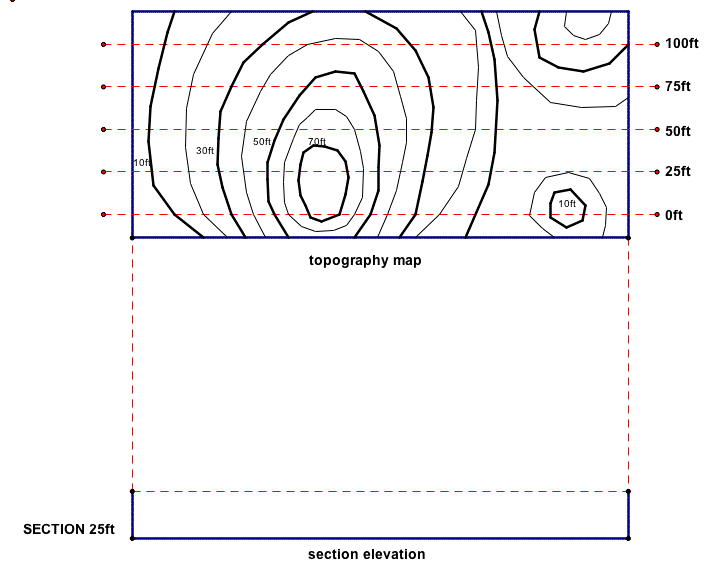
Topography
The following topography map was retrieved
from City Hall for site development. The map has been marked off
into 5 sections (0ft-100ft), horizontally across the site for
the cut and fill process. Draw the section cut 25ft by
hand (or with Geometer's Sketchpad). Let 1/4" = 10'-0"
for the vertical heights of the different elevations (10ft-70ft),
and label the line "existing elevation line" as in Phase
I. Use the drawing below to get started, and answer the following
questions on a separate sheet of paper.
1. How could you project the topography lines
down onto your drawing, to represent the appropriate elevation
heights for section cut 25ft? (Hint: look at the intersection
between the topography lines and the dashed section cuts).
2. How could you represent the height of each
of the topography lines on the section elevation?
3. Which horizontal section cut (dashed line)
on the topography map looks like it would give us the best representation
of the existing site conditions (i.e. which cut will show the
most elevation changes)? Why?
4. Describe how the elevations would look
if the section cuts were taken perpendicular (or vertically)
to the dashed cut lines drawn below. To get an accurate representation
of the existing site conditions, do you think 5 cuts vertically
across the site would be enough? Why or why not?
Click here
to use the GSP file for this problem.
One Correct Student Response
The following represents a sample student response
to the questions and drawing given in the homework problem above.
Note there are more than one possible correct student answers
to each question, and should be discussed as a class.
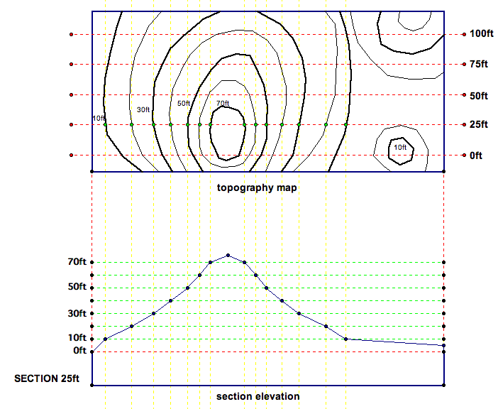
Question Responses:
1. Use the points of intersection between the
dashed cut line and the topography lines. Then, draw lines perpendicular
to the cut lines onto the elevation drawing below. These lines
represent the points on the elevation that meet each topography
line. Then, by determining the height of these points on the elevation,
the points can be connected to generate the elevation of the section.
2. Draw the height of each topography line
on the section elevation, using the given scale of 1/4" =
10'-0".
3. Section cut line 0ft because it intersects
the most topography lines of all the section cuts. Therefore elevation
at section 0ft will show the most elevation changes.
4. The section cuts would be shorter, and have
different elevations. Most of the elevation cuts would not intersect
the highest point on the site, and so most of them would look
very flat. I don't think 5 cuts would be enough because the site
is too long and 5 cuts would not give an accurate estimate of
the existing conditions. More cuts would have to be taken.
Return
to Essay 3 - Site Planning Activities