
Navigation
Pilots use this colorful, convoluted - looking map called a world aeronautical chart or navigation chart to aid them in flying from one point to another. The following pictures are close-ups of this navigational chart with added explanations. The largest city in yellow is Atlanta, Georgia. If you notice, there are squares or quadrangles evident throughout the map. In each 'square' is a number like 46 or 54. These are maximum elevation figures represented in thousands and hundreds of feet above mean sea level. The first or larger number represents the thousands and the smaller or second value is in the hundreds value.
Another feature, if you look carefully, is that the sides of each quadrangle is composed of tick marks. These tick marks represent lines of latitude and longitude.
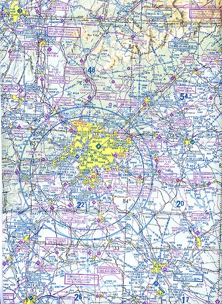
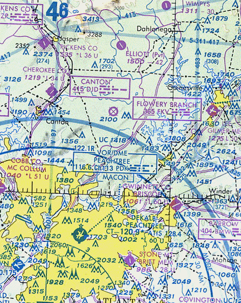
The area in the picture below is a close - up of the north side of Atlanta and part of North Georgia. For example, the 46 refers to the maximum elevation figure in that particular area. The 4 is for 4000 feet and the smaller 6 is for 600 feet giving a total of 4,600 feet. The maximum elevation figure (i.e. the 46) or MEF is based on information available concerning the highest known feature in each quadrangle, including terrain and obstructions like trees, towers, antennas, etc.
One glance and you can see that there are so many differing numbers that have, it turns out, various meanings. There are obstruction heights, frequencies, and maximum elevation figures that the pilot must be familiar with. The pilot must have the ability to jump from one unit to another fairly quickly. For example, values in feet versus values in meters; heights, frequencies; the pilot must also be able to keep them separate in his/her mind.
Observe the circular 'scatter plot of dots' in the upper left quadrant. This is a nondirectional radiobeacon (NDB), which is a low or medium frequency radio beacon that transmits nondirectional signals whereby the pilot of an aircraft can determine bearings and home in on the station. The pilot needs to understand different units of measurement, such as kHz or Hz or MHz. These are kilo hertz, hertz and mega hertz respectively. What does kilo and mega mean? Units in math problems (especially word problems) are easily ignored by the math student but should be given prompt attention.
If you notice the object directly above the number 2550 that looks like a circle with three sides and a dot in the middle, that is called a VORTAC. This is unit or device that combines the VOR (Very High Frequency Omnidirectional Range navigational aid) with a DME (Distance Measuring Equipment for measuring distance from the plane to the ground). The VOR system operates in the VHF frequency band, from 108.0 to 117.95 MHz. To simplify, the reception of VHF signals is a line of sight situation. You must know if you are in 1 of four elevation ranges (i.e., 1000 - 18,000 feet, 1,000 - 14,500 feet, 14,500 - 60,000 feet and 18,000 - 45,000 feet) and know the number of nautical miles that matches each specific range. The point is again, the units in miles is nautical miles and the pilot must know the difference between a mile and a nautical mile, its a number.
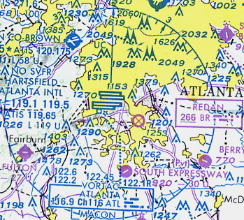
If you look at the lower left quadrant, you will eventually notice the numbers 122.6, 122.2, 122.45 or the 116.9 inside the Atlanta rectangle. These values are frequencies the pilot uses for navigation. This value is the station or frequency the pilot should tune to in a particular area. They can then tune their radio navigation equipment to a signal from this station. A needle on the navigation equipment tells the pilot where they are flying to or from the station; if he/she is on course or not.
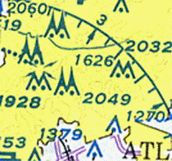
In the figure above there are several 'pointed' figures mostly in sets of two. These are obstructions that are at least one thousand feet or higher. The actual value is written next to them. There is a pair that looks like an 'M' next to the value 1928 that has arrows above it. This means that the obstruction has high-intensity lights that may operate part time.
To visit a very good web site about aircraft navigation click on: