When planning the design and construction of a building, architects and engineers must first consider the existing conditions of the site. Most often, the given site is not level and must be modified before any construction can begin. So, the cut and fill process is typically one of the first construction processes to take place on a site.
Without computer software to determine the amount of land to be added or removed, we can do simple calculations to estimate the cut and fill volume of any site. First, the site is divided into sections. Essentially, the site is "sliced" into segments of land, at a specified fixed distance apart, so we can look at each segment individually. Section cuts are drawn based on the topography of the land in order to accurately represent the land that is being evaluated.
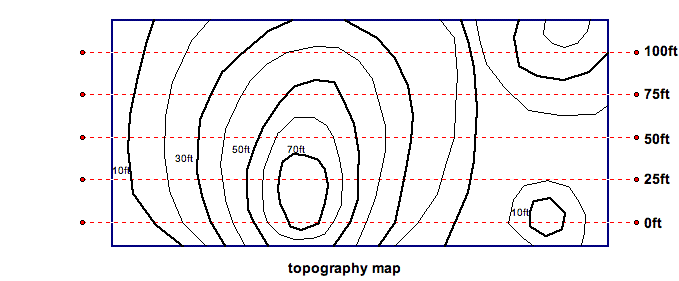
The topography map describes the existing slopes of the land, and allows us to draw site elevations in our section cuts.
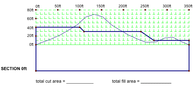
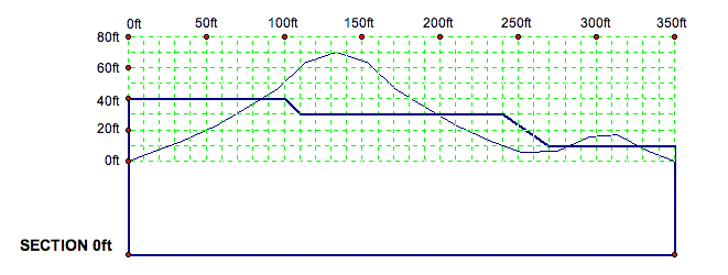
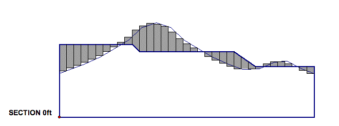
Each line on the topography map represents a change in elevation of 10 feet. So the section at 0ft (the red dashed line above) looks like this in elevation:

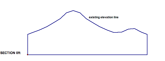
Then, by removing the elevation lines, we get the following section for the existing site elevation:
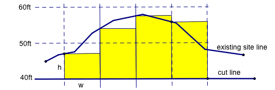
Now that we have two dimensional section cuts, we can estimate the area to be cut and filled in the site. On each section cut the desired land topography is represented as a "cut line" overlaid on the line of the existing land topography. This gives us two lines on every section, and shows us how much of the existing area must be removed or added. Then, the area between these lines is calculated to find the cut and fill areas for each section.
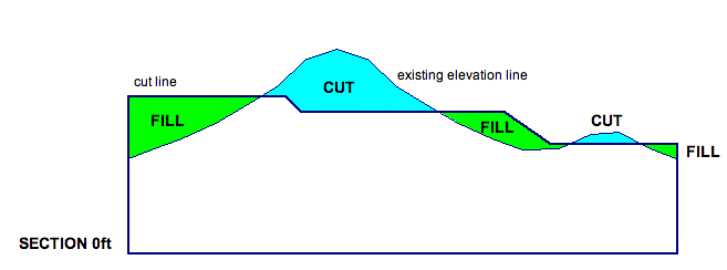
The diagrams below represent the area between the existing elevation line and the cut line. First, we mark the land that must be added to the site to achieve our desired land topography. This area is marked "fill."
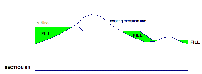
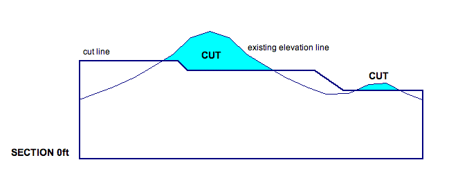
Next, we mark the land that must be removed from the site to achieve our desired land topography. This area is marked "cut."
By combining the two diagrams, we can see begin to estimate how much land area must be cut from the site, and how much land area must be filled in the site to level the site for construction.
Now, once the section areas have been found, we must account for the additional length of the site (the land between the section cuts) to be able to estimate the volume of the land cut or filled. Finally, after computing the necessary values we are able to determine not only how much land must be removed from or brought to the site, but also where that land must be specifically taken from or brought to. Removing or adding land to any site is a costly process, so it is important that our estimations be made as close to the existing conditions as possible. Once we know how much land to cut or fill, and where to cut and fill it, work can begin to properly level the site and construct our building.
The following activity uses the mathematical concepts of estimating area and volume to solve a realistic cut and fill problem. Each two-dimensional section cut is overlaid with a grid to allow us to estimate the area between the existing elevation line and the cut line.
To estimate area, we can divide the area under the curve into rectangles and then find the area of each rectangle. Refer to the diagram below for the process of drawing rectangles. Consistency in drawing the rectangles is very important to ensure proper balance between over and under estimation of area. Since all of the intervals are the same width of 10ft, the only estimating that you will need to do is with the height of each rectangle. For this exercise estimate the height to the nearest 2 1/2 feet (or 1/4 of the 10' X 10' square).
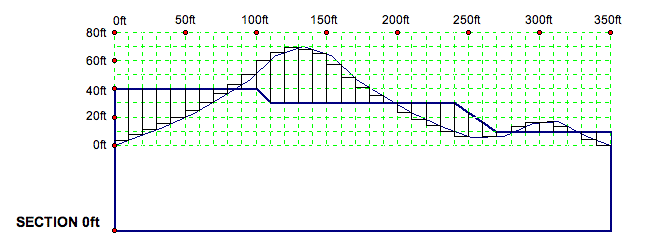
By removing the grid lines, it is easy to see the areas of the rectangles that we will be estimating. Since these rectangles will represent and overestimation in some parts, and an underestimation in others, we will consistently draw our rectangles and not worry about the area between the lines that are missed.
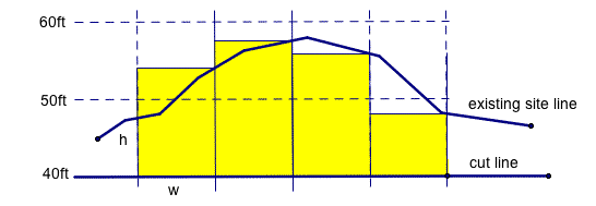
The diagrams below represent two different ways rectangles can be drawn between the existing elevation line and the cut line. The process of left and right estimation indicate the direction in which the rectangles that meet the curve and are drawn.
SITE VOLUME
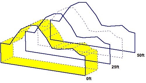
To estimate the volume, we use the area that has been determined (as width and height) and then multiply by the distance between each section (depth). Note that the first and last section is on the site boundary. Notice also that these boundary sections only have a volume on one of their sides. The remaining sections between the boundaries have land volume on each side. See the diagram below. The solid lines refer to our section cuts, and the dashed lines refer to the midpoint between the section cuts. The volume for section cut 0ft is shaded below.
ESTIMATE THE AREA
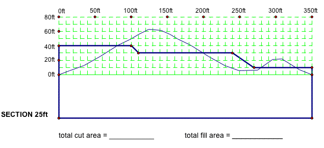
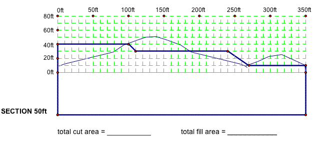
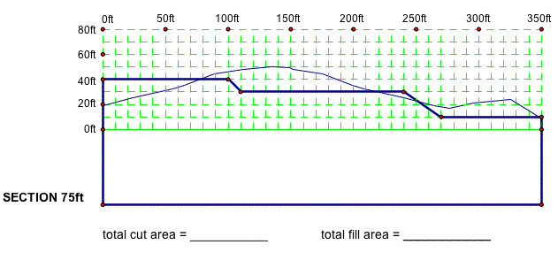
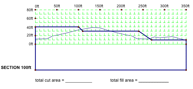
1. Use the smaller grid lines at 10 feet to estimate the amount of land area that must be cut or filled for each site section. Identify and label the areas of the section that are to be cut or filled. Be sure to include the proper units in each of your answers.
a)
b)
c)
d)
e)
2. How would the area estimates change if we chose to divide the site sections into 1 foot increments, as opposed to the 10 foot increments used above? Which grid size would produce an area estimate closer to the actual area of our site?
ESTIMATE THE VOLUME
1. Assuming our site has boundary lines at section cut 0ft and at section cut 100ft, evaluate the volume of land that must be cut or filled for each of the five sections. Use the corresponding areas you found for each section in question 1. Think about how you would determine the site depth to find volume? Use the image on page 2 to visualize the volume of the land. Be sure to include the proper units in each of your answers.
a) section 0ft
total cut volume:
total fill volume:
b) section 25ft
total cut volume:
total fill volume:
c) section 50ft
total cut volume:
total fill volume:
d) section 75ft
total cut volume:
total fill volume:
e) section 100ft
total cut volume:
total fill volume:
2. Now, write a general expression for the volume of land at a boundary line in terms of area. (i.e. Volume = Area * _____ ft). Briefly explain your answer.
Write a general expression for the volume of land at section cut that is not a boundary line in terms of area. (i.e. Volume = Area * _____ ft). Briefly explain your answer.
3. How would the estimates change if you chose to cut the site into ten 10ft sections rather than four 25ft sections? How would this affect our area estimate for each cut section as related to the actual site conditions?
ESTIMATE THE COST
1. As site developers, we must figure out how much land will be moved on our site. By finding the sum of volume to cut, and the sum of volume to fill, we can use the difference to determine whether we need to add or remove land from our site.
a) What is the sum of the volume of land that must be cut from the site?
b) What is the sum of the volume of land that must be filled on the site?
c) What is the total volume of land that must be added or removed from the entire site?
2. Finally, to develop our site we are required to add or remove the volume of land calculated in question 1c above. To move this land, we must hire dump trucks. Therefore, it is important for us to know how many dump truck loads will be required to reasonably estimate the cost to level the site.
a) If the dimensions of a dump truck bed are 10 feet high, 8 feet wide, and 15 feet long, how many cubic feet of land can one dump truck carry?
b) How many dump truck loads are required to level our site?
3. To remove a dump truck load from a site, the cost is $50. However, to add land to our site, the cost is $100 per load- $50 for transportation, and $50 to purchase the additional land.
a) What is the total cost for adding/removing land from our site?
b) As a site planner, we would like to offer the client recommendation on how to reduce this cost. What practical recommendations can be made to lower our cost? Why?
Return
to Essay 3 - Site Planning Activities